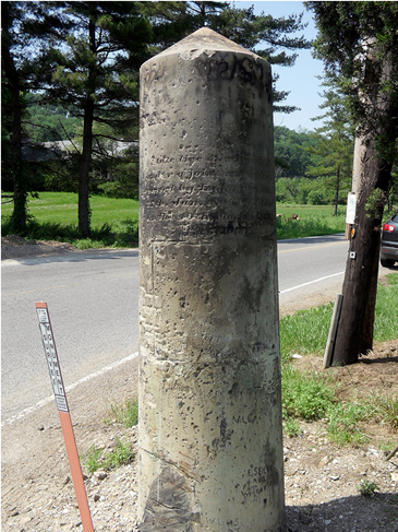
Did you know that the stone monument at Stateline Road and US 50 is a marker for the 1st Principal Meridian?
In October 1798, Israel Ludlow, Deputy Surveyor and a founder of Cincinnati, was appointed by President George Washington to survey this section of the Northwest Territory. He ran a line north from the middle of the mouth of the Great Miami River, as a meridian from which to lay off the government townships and sections. The lower part of the Ohio-Indiana line was thus first laid out for use as a standard meridian for land surveys and not for a state boundary.
Indiana accepted the meridian, defined by Congress in 1802, as its boundary when admitted as a state in 1816.
Doubts had arisen in 1835 as to the point on the Ohio River at which the boundary of Ohio and Indiana began. Joint commission from both states were appointed to examine the boundary. On November 21,1837, Nathaniel L. Squibb was appointed to re-survey and monument the boundary line between Ohio and Indiana from the mouth of the Great Miami River to the point where the road from Lawrenceburg to Elizabethtown crossed (current US 50), this had also been the towpath of the Whitewater Canal.. Assisting Squibb was Joseph Gest, surveyor of the city of Cincinnati.
The survey was completed and marked the same as originally surveyed by Israel Ludlow. In the line (in 1837), Nathaniel Squibb located to correspond as nearly as possible with the 1798 field notes of Israel Ludlow.
In connection with Squibb’s work the commissioners on November 27, 1838, set two monuments of solid freestone. The two monuments were nine feet in length, each resting three feet below the surface of the ground on a square block of freestone, embedded in a cubic yard of broken stone to protect them from the action of the frost. The monuments weighed 5,000 pounds and were believed to be impervious to frost and very durable.
One of the stone monuments was placed on the west bank of the Great Miami River at its junction with the Ohio River. The other, about 3 miles north, where it crosses the towpath for the old Whitewater Canal (now U.S. Highway #50).
The monument near the mouth of the Great Miami River “disappeared” around the turn of the century, due to sediment buildup from multiple floods.
In October 1981, Kentucky, Indiana and Ohio ended a dispute about the location of Kentucky‘s northern boundary. Kentucky agreed to recognize the low water line as it was in 1792 when Kentucky became a state. After the agreement, survey teams and the staff at the U.S. Geological Survey in Reston, VA., worked to draw the 525 miles of negotiated boundary lines onto maps. They had to figure out where Ohio stopped and Indiana began.
In August 1983, a group of three surveyors - Roger Woodfill, of Lawrenceburg, Brad Andrew Jr., of Bedford, Ky., and William Kreisle of Louisville, along with their aides, set out to locate the monument near the mouth of the Great Miami. This was certainly not an easy task. The expedition began their task by going by motorboat from Tanner’s Creek and then up the Ohio River to an island near where the Great Miami meets the Ohio River. The original monument was found exactly where the 1930’s railroad survey stated it to be. On a subsequent trip, the crew then carried a 300 lb., 7 foot long concrete beam along the 55 foot long path that they had beaten out with machetes and shovels thru the 12 foot high weeds. The path ended at the location of the original monument where the men had dug a 5 ½ foot deep hole down to the top of the monument, exposing the “buried treasure“. The new concrete monument was set atop the original, leaving about two feet out of the ground, so it can be easily found.
On the sides of the original marker were the words Ohio chiseled on the east side and Indiana on the west side. The monument at Stateline Rd. and US 50 is incised on the south side with “state line as resurveyed under a joint resolution passed by Indiana on the 27th, Jan. and by Ohio on the 10th, March 1837.“ On the north side is incised “ Erected Nov. 27th, 1838” on the east side OHIO and on the west side INDIANA. A descriptive bronze tablet was attached by the D.A.R. in 1929. ( This tablet has since fallen off and has yet to be set back into place).
These monuments and one set in 1915 at the northwest corner of Ohio, are believed to be the only authoritative monuments on the entire Ohio-Indiana line.
Sources are the Ohio Archaeological and Historical Society Publications, Volume 4 and Dearborn County surveyor, Roger Woodfill.
|